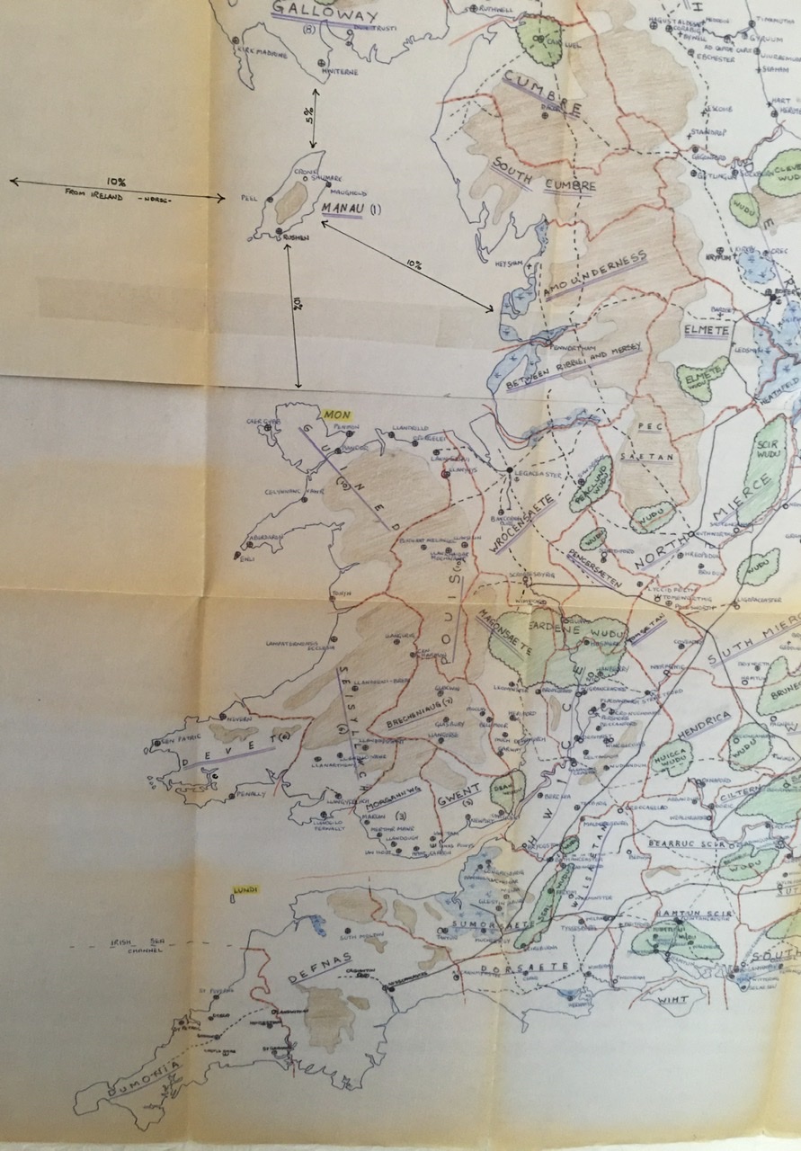
A short post as Nundunket and Jolly Broom Man are interested in the map. I took a few minutes to unfold the master map I created back in the early 1980's and to get some photo's. Its a big beast printed out on three sheets of A3 or maybe A2 paper, I should have measured it shouldn't I. The original was hand copied from the OS Britain Before the Norman Conquest map (now sadly out of print).onto tracing paper selecting the details I needed and adding a few other things. I then took it down to a printing and copying shop in York (when they still existed in most towns) who copied it onto paper for me on a dyeline printer. I hand coloured the dyeline print and taped the three sections together. It has spent most of the last 35 - 40 years folded up which is why it hasn't faded too much. I got bored with colouring in the hills and mountains within Scotland which is why the detailing stops at the line of the Firths of Clyde and Forth. Most of the rest of the map would have been brown and for the solo campaign I don't need that level of detail anyway.
Dyeline was a system used before digital printing to copy and print large plans. Because it pre-dates digital imaging technology there is no electronic back up copy. which has always worried me. I really should get a back up although who would need it is beyond me.
 |
The entire master multiplayer version of the map
|
I'm quite proud of it to be honest. I was a geology student and then worked for a very short time in a County Council road planning department and was taught a bit about drawing up plans which helped a lot with this. It's the only evidence I have of my abilities as a map maker from before the computerisation of imaging and storage.
 |
| The South Eastern part in detail |
 |
| The South West part in more detail |
 |
| Southern Scotland & Northern England |
The bit of the map showing Northern Scotland doesn't seem to want to load at the moment. I will try again later.
Be safe and take care of yourselves


Thank you ever so much for digging that out mate it’s really appreciated. Funny enough I did Geology A level with a view to going into the petro chemical industry. Never happened of course but I still harbour a deep love of maps. This is going to come in useful somehow...I know it. Good job you kept it safe all these years. I’m originally from the land of the Hwicce by the way!
ReplyDeleteWow! That’s an awesome piece of work.
ReplyDeleteFascinating to see how ‘wet’ much of the country was then, including my own homeland of Lindsey which was in effect an island and had fewer outlets to the sea judging by that map. It really makes sense of things to see that.
Thanks for sharing it.
And I currently live in Lindsey alongside the Humber Bridge although I originally hail from the disputed lands of betwixt Ribble and Mersey (or possibly Amounderness depending if the Ribble was the boundary).
DeleteAh, the Barton area. I keep meaning to visit there for the Ropewalk museum. I must do that when the Covid crisis is over. Sadly I have fewer reasons to visit that part of the country now.
DeleteThis is just a fantastic post - thanks very much for publishing the scans - remarkable. As a native of the Mersey area, now living just off the map next to Dunbarr, I am delighted just to have a chance to browse it. Excellent.
ReplyDeleteGlad you liked it. Scotland is on the main map and if I can get the last image to post I will add the Northern most portion of the map as a more detailed image.
Delete